Professional survey team conducting topographical survey in Zanzibar
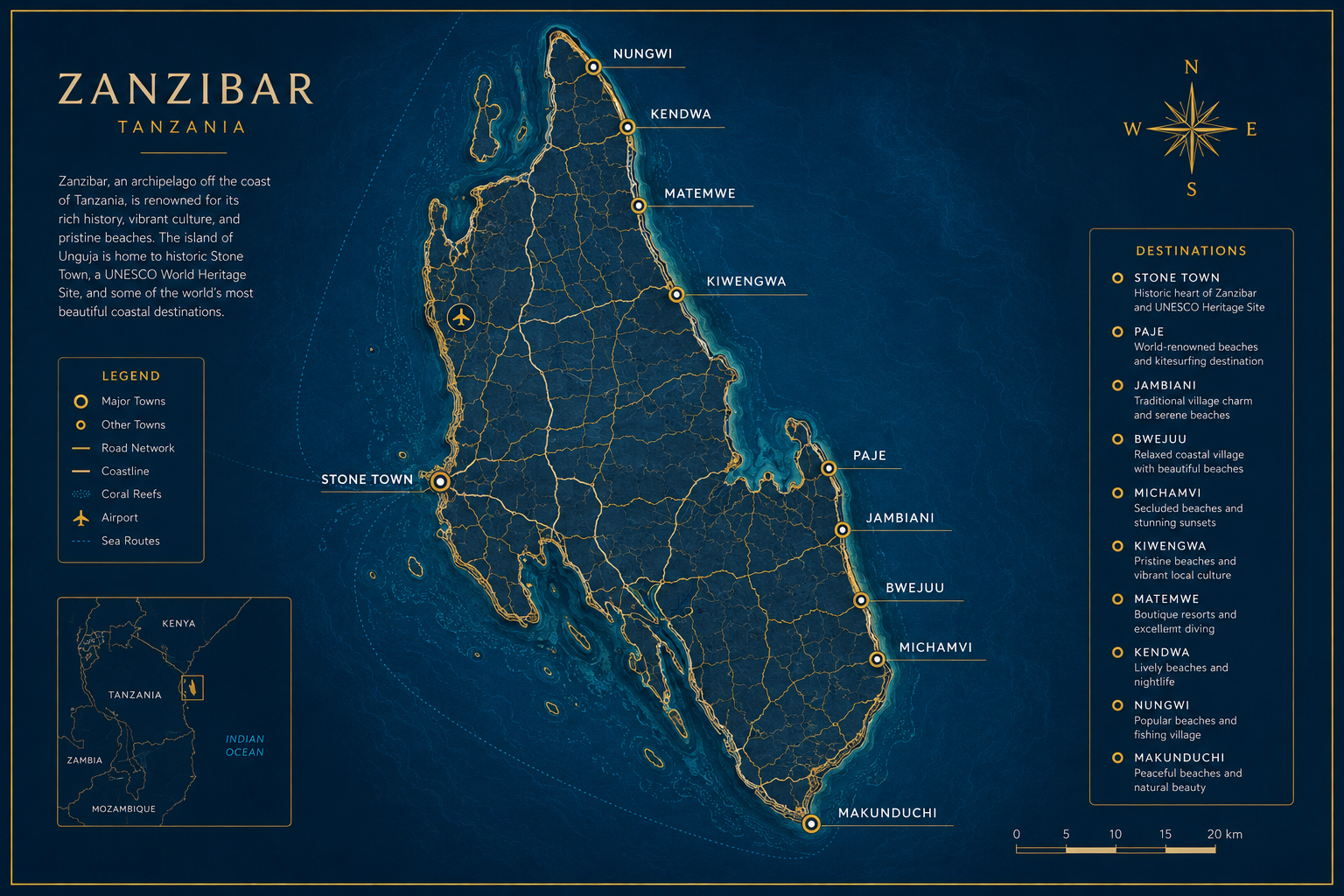
Zanzibar's Most Trusted Survey Company

Zanzibar's Leading Surveying & Geospatial Solutions Partner
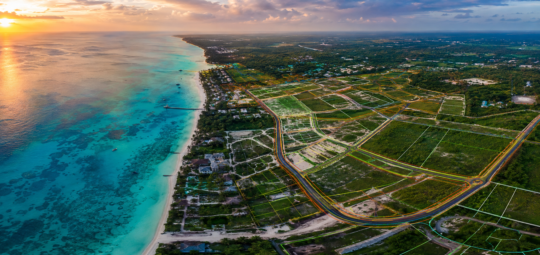
Land Surveys GIS Mapping Drone Surveys Hydrographic Surveys Engineering Surveys

Professional surveying and geospatial solutions for developers, government, and international organizations across Zanzibar and East Africa.

500+ Surveys Completed
15+ Years Experience
98% Client Satisfaction
24h Fast Turnaround
500+ Surveys Completed
15+ Years Combined Experience
98% Client Satisfaction
24h Fast Turnaround Time
Why Choose Us

Why Choose Zanzibaba Survey & Geospatial

We combine local expertise with international standards to deliver exceptional surveying and geospatial solutions.

Licensed surveyors using advanced GNSS equipment in Zanzibar

Licensed & Experienced Professionals

Our team comprises licensed surveyors, certified GIS specialists, and drone pilots with decades of combined experience in Zanzibar and East Africa.

Advanced Survey Technology

We invest in the latest GNSS receivers, robotic total stations, survey drones, and GIS software to ensure precision and efficiency.

Fast Project Delivery

Our efficient workflows and dedicated project managers ensure timely delivery without compromising quality standards.

High Accuracy Results

Centimeter-level accuracy achieved through rigorous quality control procedures and calibration of all survey equipment.

Zanzibar Local Expertise

Deep understanding of Zanzibar's land regulations, terrain challenges, and local requirements ensures smooth project execution.

Dedicated Client Support

From initial consultation to final delivery, our responsive team provides ongoing support and clear communication throughout.

Our Services

Comprehensive Survey & Geospatial Solutions

From traditional land surveys to cutting-edge drone mapping and hydrographic surveys, we deliver precision solutions for every project.

Land Surveying

  • Topographical Surveys
  • Boundary Surveys
  • Cadastral Surveys
  • Plot Subdivision
View Services

GIS & Geospatial

  • GIS Mapping
  • Spatial Analysis
  • Asset Mapping
View Services

Drone Mapping

  • Drone Surveys
  • Photogrammetry
  • 3D Terrain Modeling
View Services

Hydrographic Services

  • Bathymetric Surveys
  • Coastal Mapping
View Services

Engineering Surveys

  • Construction Setting Out
  • Infrastructure Surveys
  • Utility Surveys
View Services
View All Services
Our Work

Featured Projects

Explore our portfolio of successful survey and geospatial projects across Zanzibar and Tanzania.

Hotels & Resorts

Luxury Beachfront Resort Survey

Complete topographical and hydrographic survey for a 5-star resort development in Nungwi.

Infrastructure

Mainland-Link Road Survey

Engineering surveys for major road infrastructure connecting Zanzibar's districts.

Land Development

Affordable Housing Project

Plot subdivision and boundary surveys for 500-unit housing development.

Coastal Projects

Port Expansion Bathymetric Survey

Detailed bathymetric surveys for Zanzibar's commercial port expansion.

View All Projects
Project Case Studies

Success Stories

Explore detailed case studies of our most impactful survey and geospatial projects.

Topographical survey for luxury resort development in Nungwi Zanzibar
Topographical Survey 2024

Resort Development Feasibility Study

Comprehensive topographical survey and feasibility analysis for a luxury beachfront resort development in Nungwi, Zanzibar.

15 ha Area Surveyed
3 weeks Project Duration
Plot subdivision survey for residential development in Zanzibar
Plot Subdivision 2023

Urban Infrastructure Asset Mapping

Created a comprehensive GIS database of urban infrastructure including roads, water networks, and public facilities for Zanzibar City Council.

120 km Road Network
85 km Water Network
Engineering survey for coastal road infrastructure project Zanzibar
Engineering Survey 2024

Infrastructure Survey Documentation

High-resolution drone photogrammetry survey of infrastructure development for preservation planning.

2.5 ha Area Covered
2 cm Ground Resolution
Hydrographic survey vessel mapping coastal waters Zanzibar
Hydrographic Survey 2023

Port Expansion Bathymetric Survey

Detailed bathymetric surveys for Zanzibar's commercial port expansion to accommodate larger vessels.

2.5 km² Survey Area
15 m Max Depth
View All Case Studies
Our Equipment

Precision Survey Equipment

We use industry-leading equipment to ensure accurate and reliable survey results.

GNSS RTK survey equipment for centimeter accuracy positioning Zanzibar

Leica GS18 T GNSS RTK

High-precision GNSS receiver with RTK capability for centimeter-level positioning.

Accuracy: ±8mm + 1ppm Range: 40 km
Robotic total station for precision angle and distance measurements

Leica TS16 Total Station

Robotic total station with automated target recognition for efficient surveys.

Angle: 1" Distance: 5 km
DJI Matrice survey drone for aerial mapping photogrammetry Zanzibar

DJI Matrice 350 RTK

Professional survey drone with RTK positioning for aerial mapping.

Flight Time: 55 min Payload: 2.7 kg
Echo sounder hydrographic survey equipment for bathymetric mapping

Knudsen 3260 Echo Sounder

High-resolution bathymetric survey system for shallow water mapping.

Frequency: 200 kHz Depth: 0.5-200 m
GIS mapping software displaying spatial data analysis Zanzibar

Trimble CX Scanner

3D laser scanner for detailed topographic mapping and as-built surveys.

Range: 80 m Scan Rate: 1M pts/sec
Technology

Advanced Equipment & Technology

We invest in the latest surveying and mapping technology to deliver precision results for every project.

GNSS RTK

Centimeter-level positioning accuracy

Total Station

Precision optical measurements

Survey Drones

UAV aerial mapping systems

GIS Software

ArcGIS & QGIS platforms

Hydrographic Equipment

Echo sounders & sonar

Explore Our Technology
Satisfied clients testimonial section background Zanzibar survey
Testimonials

What Our Clients Say

Trusted by leading developers, government agencies, and international organizations across Zanzibar.

"Zanzibaba Survey provided exceptional service for our resort development project. Their attention to detail and professional approach exceeded our expectations. The hydrographic survey data was invaluable for our coastal construction."

JM
James Mitchell Project Director, Azure Beach Resort

"We have worked with Zanzibaba Survey on multiple infrastructure projects. Their drone survey capabilities and GIS expertise have been instrumental in our planning and design processes. Highly recommended."

AK
Dr. Amina Khouri Chief Engineer, Zanzibar Roads Agency

"The plot subdivision survey was completed efficiently and all documentation was handled professionally. Zanzibaba Survey made the entire land registration process smooth and hassle-free."

SM
Sarah Mwangi Property Developer, Zanzibar
Education Hub

Surveying Knowledge Center

Learn about surveying concepts, land investment, and the technology behind our services.

Surveying education and professional training resources
Fundamentals

What Is Land Surveying?

Understanding the science and profession of determining positions on Earth's surface.

Read More
Guide

Plot Subdivision Guide

How land is divided into smaller parcels for development or sale.

Read More
Technology

GIS Explained

Geographic Information Systems for spatial data analysis and visualization.

Read More
Innovation

Drone Survey Benefits

How drone technology is revolutionizing surveying efficiency.

Read More
Investment

Zanzibar Land Development Guide

Everything you need to know about land investment in Zanzibar.

Read More
Explore Education Hub
Our Coverage

Service Areas Across Zanzibar

We provide surveying services throughout the Zanzibar Archipelago and mainland Tanzania.

Service coverage map showing survey operations across Zanzibar archipelago

Unguja (Zanzibar Island)

  • Stone Town
  • Nungwi
  • Kendwa
  • Mangapwani
  • Paje
  • Jambiani

Pemba Island

  • Chake Chake
  • Wete
  • Mkoani
  • Chwaka

Mainland Tanzania

  • Dar es Salaam
  • Tanga
  • Morogoro
  • Coast Region

East Africa

  • Kenya
  • Uganda
  • Mozambique
Contact Zanzibaba Survey for professional surveying services in Zanzibar

Ready to Start Your Survey Project?

Contact us today for a free consultation and competitive quote. Our team of experts is ready to assist with your surveying and geospatial needs.